Finding the Site
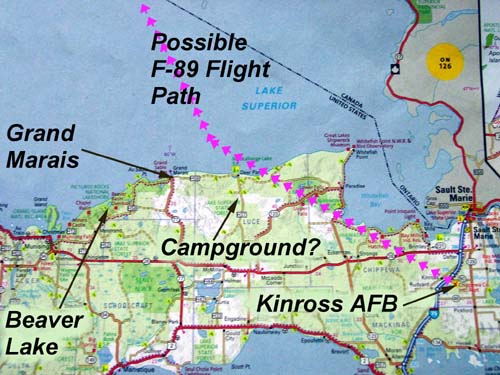 Michigan's Upper Pennisula This map shows Kinross Air Force Base, where the F-89 was scrambled and an approximate flight path for the F-89 based on information in the accident report. My memory of the vacation was that our destination was Grand Marais, which I remember my brother telling me, many years later was in Michigan. I remember that we stayed at a campground that was inland from the Lake Superior lakeshore – which may have been near Deer Park. Beaver Lake is the area I believe I had the encounter with the man who may have been Lt. Wilson. I believe I was pointing to Grand Island when I asked the man if that was the point of land he was referring to when he talked about the aircraft "accident" site. Munising is located directly south of Grand Island. This is where I believe we bought the Michigan souvenir plate for my grandmother Polly Osolinski. It is also the place I remember by mother referring to when we were in the car on our way to Grand Marais, where she said to us "This is Munising. We are almost there."
When I first started to remember the incident in May 2001, all I knew was that the event was related to Grand Marais. I am not sure when I experienced the memory recall when my brother and I were looking at the atlas and he told me that Grand Marais was in Michigan. I know that before I took my trip to Madison in 2001, I was trying to determine the location of the encounter. At that time, I could recall the part of the encounter when I point to "a point" of land off to our left and Wilson tells me it was an island. By looking at a map and inferring from the flight path he pointed out over the lake, I determined that the island we saw was Grand Island in Michigan. This implied that the hill we climbed was to the east in Pictured Rocks National Lakeshore.
One of the objectives of my trip east in 2001 was to find the location of the hill. Due to commitments at work, I was only able to take a week off for holidays. This meant I had only a day for my visit to the Upper Peninsula to visit Kinross, Grand Marais and to search for the hill.
When I got to Munising, I stopped to pick up a map of Pictured Rocks National Lakeshore. Looking at the map, I decided to first check out Miner's Point, which was the first accessible spot to the east of Grand Island. When I got to the spot, I immediately knew that this was not the site. Disappointed, I decided to drive to Grand Marais and on to Deer Park. I got to one place east of Grand Marais that I thought was close to the campground we had stayed at, but I didn't have time to look around for the campground. I then drove over to Kinross to see the airfield. After this. I drove back to Pictured Rocks and parked at the Chapel Lake parking area. I walked the trail past Chapel Falls towards the point of land above Lake Superior. I determined that this was also not the hill I had been to. At this time, I still had no recollection of our discussion about Beaver Lake below us.
The next morning I drove out to the Beaver Basin viewpoint, which turned out to be a very poor viewpoint because it was almost entirely blocked by trees. I then drove down to Little Beaver Campground. When I got there, I thought that this can't be it, because I couldn't see the hill.
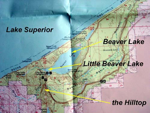 Beaver Basin in Pictured Rocks National Lakeshore This area is east of Munising and west of Grand Marais, Michigan. "The Hilltop" is the place I think we stopped to rest that overlooked Beaver Lake and Little Beaver Lake. I think we were seated facing north.
After I had returned to Vancouver from Madison, I spent more time looking at the map. It was then that I was able to remember that the man had pointed out to the two lakes below us, when we first got to the top of the hill. He had told me the larger lake was called Beaver Lake, and the smaller lake that was closer to us was called "Little Beaver Lake". I remembered that I had told him that the big lake should be called "Big Beaver Lake" if the little one was called "Little Beaver Lake".
When I looked at the map, I was able to see that there was a hill above Little Beaver Lake that overlooked the basin and Lake Superior. When I returned the following year, I was anxious to check out the hill. One thing that I had not realized was that the hillside I had climbed in 1957 had changed considerably because the trees had been allowed to grow. The area had all been logged in the 1940s and 1950s, before the National Lakeshore was established in the early 1960s. When I had climbed the hill, there were only bushes and very small trees, so I guess it had been recently logged. One thing I was able to remember is that we had started our walk near the shore of Little Beaver Lake and had walked some distance on a trail by a creek through woods. The man had made a comment about how nice and cool it was in the shade by the creek. When we climbed the hill, I remember that there was a twisting trail that seemed steep to me. It was sandy, like many areas you find in Pictured Rocks National Lakeshore. I got very tired in the hot sun, and the man kept encouraging me to keep walking, telling me that we would have a good rest once we got to the top of the hill.