F-89 Flight Reconstruction - Intercept of RCAF C-47
This reconstruction of the flight of the F-89 is derived from the position, time, bearing and altitude information which is provided within the USAF Official Accident Report. The basic information required to reconstruct the flight is provided below:
Start Position and Time
The start position for the flight was Kinross Air Base at 18:22 EST.
End Position and Time
The end position for the F-89 when its return "merged" with its intercept target was 4800 N and 8649 W. The time the F-89 return merged with the target on radar is 18:55 EST.
Initial Bearing
The initial bearing for the F-89 was 300 degrees magnetic. Given magnetic declination of 1 degree 30 seconds west, the actual initial bearing would be 298.30T.
Final Turn and Bearing
The final bearing provided by GCI to the F-89 was a starboard turn to 20 degrees magnetic (18.30T) at 18:51 EST.
Previous to Final Turn and Bearing
The previous to final turn was a port turn to 270 degrees magnetic (268.30T) at 18:47 EST.
Pigeons to Home Plate
"Pigeons to Home Plate" was requested by the pilot about 18:50 EST. This (I believe) was a request for a return bearing and distance to home base and was provided by GCI as "150 - 125 miles". I take this to mean bearing of 150 degrees magnetic and 125 miles distance on the return vector.
My Analysis
The primary source for all of this information, with the exception of the actual final merge coordinates, comes from the statement made by GCI Controller, Lt. Douglas Stuart. The final coordinates of the merge location comes from USAF telexes and from the RCAF SAR report.
When this information is transformed to a map, it is revealed that some information is missing and some information may be inaccurate or incomplete. I suggest that some of the inaccurate information may be simple typographical errors. It is also possible that mistakes were deliberately introduced into the report by USAF authorities to create ambiguity about the actual flight path for the F-89.
First Ommission or Error
The first ommission or error relates to the initial vector. If the initial bearing was 300 degrees magnetic, then the pilot had to make an additional starboard turn sometime early in the flight. Without making this turn, the pilot would never have made it over the Canadian border where the intercept occured with the bogie. Alternatively, it is possible that the initial bearing was perhaps 320 or 330 degrees. The initial bearing of 300 degrees is only mentioned once, and therefore it could be a typographical mistake or carefully inserted error.
Second Error
I think the "Pigeons to Home Plate" bearing and distance measurements are both probably wrong. If the pilot was only 125 miles from base at 18:50 EST, then the F-89 had to fly a minium of 38 miles in the final 5 minutes. This is equivalent to a speed of 460 mph. If the F-89 flew a net distance of 125 miles in the first 28 minutes of the flight, the average net speed (not accounting for turns) for the F-89 would be 268 mph. It would make more sense for the pilot to be slowing down during the final minutes of the intercept, because the pilot was descending and more importantly, was preparing an intercept with an aircraft whose cruising velocity was about 170 mph (assuming for a minute that the F-89 was actually intercepting a C-47, DC-3, or other propeller powered aircraft from that period).
It is probable that the returnn bearing should have been closer to 130 or 140 degrees, although this may be a minor discrepancy, since the purpose of the vector was to get the pilot back to the region of the home airfield - and all bearings appear to be in increments of 10 degrees, so there is some intrinsic error.
In reconstructing the flight of the F-89, I tried to proceed from an assumption of minimal introduced errors and ommissions.
There are two possible scenarios of alternative F-89 flight paths, based on the USAF report.
Scenario 1
I base this scenario on assuming the initial bearing was correctly stated as 300 degrees magnetic. This implies a starboard turn sometime early in the flight. I investigated alternative sub-scenarios based on bearings for the second leg of 320, 330, 340, 350, and 0 degrees magnetic. The most logical sub-scenario seemed to be a second leg with bearing of 330 degrees with a turn made about 13 minutes into the flight.
Initial Bearing: 300 degrees at 18:22 EST
Starboard Turn to 330 degrees at 18:31 EST
Port Turn to 270 degrees at 18:47 EST
Starboard turn to 20 degrees at 18:50 EST
Contact at 18:55 EST
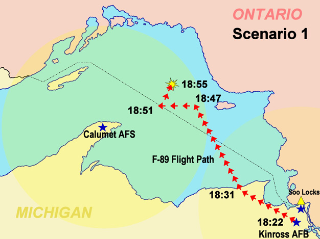 Scenario 1: F-89 Intercept
Scenario 2
I base this scenario on assuming that there was no additional course change which was omitted in the Stuart's Statement. I therefore hypothesize the initial bearing was reported in error, and was perhaps most likely a bearing of 320 degrees.
Initial Bearing: 320 degrees at 18:22 EST
Port Turn to 270 degrees at 18:47 EST
Starboard Turn to 20 degrees at 18:50 EST
Contact at 18:55 EST
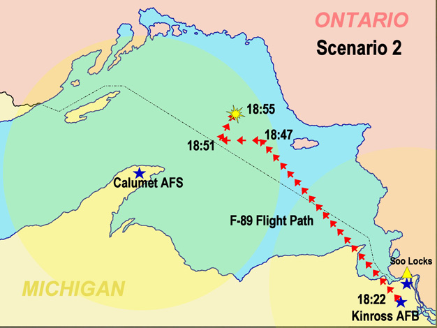 Scenario 2: F-89 Intercept
Implied Flight of C-47
What does the flight path of the F-89 suggest about the flight path of the RCAF C-47, under the two scenarios I have described here?
Firstly, I suggest that the initial intercept bearing would be based on providing the F-89 an intercept with the C-47 based on its bearing, position and velocity at the time the F-89 was scrambled, about 18:15 EST. The final turns during the intercept would be course adjustments made to zero in on the "unidentified aircraft" as it made its way from west to east across Lake Superior. My research suggests that the best intercept angle was from a back angle. A head on intercept risks enemy fire. A broadside intercept is too likely to miss the aircraft and provides less opportunity to for course adjustment. It also provides higher likelihood of the bogie spotting and attacking the interceptor. An intercept from directly behind provides best opportunities to adjust course in the pursuit, however it is much more difficult to identify an aircraft from directly behind.
Implied Flight of C-47 Under Scenario 1
Under Scenario 1, there is a course adjustment made about 10 minutes into the flight. This suggests to me that the C-47 would also have made a course adjustment just prior to the F-89 course change.
The initial bearing for the F-89 is consistent with an interception for an aircraft which had a flight plan in a straight line across Lake Superior from Fort William to Sault Ste. Marie, but was flying for some unknown reason, about 30 miles south of its intended flight plan.
The course change is consistent with a plane realizing it was off course, and then making a major course correction to get back over the border, with the F-89 pursueing the aircraft into Canadian air space.
The problems I see with this scenario are that the C-47 had flown right over Fort William on its way to Sault Ste. Marie. Even if the C-47 had made a major error in setting up its next course bearing, it seems very difficult to imagine a likely intercept scenario for the F-89 and C-47 based on a flight departing Fort William, shortly before the alert was called.
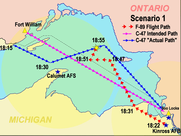 Scenario 1: F-89 and C-47 Intercept
Note that under this scenario, the planned flight path for the C-47 is far south of the location where the radar returns from the two aircraft merged on radar. If the actual flight plan for the C-47 was a straight line from Fort William to Sault Ste. Marie, then it is highly unlikely that the C-47 would have been in the area where the radar returns merged unless the C-47 was making multiple extreme navigation errors, contrary to the statements made by Gerald Fosberg.
Implied Flight of C-47 Under Scenario 2
In a letter referring to the Kinross Incident, the RCAF stated that the course of the C-47 would have been entirely within Canadian territory. This implies that the C-47 flight plan was not a straight line from Fort William to Sault Ste. Marie, as was stated to me by Flight Lieutenant Gerald Fosberg, but must have consisted of two legs. In this mapped scenario, I look at one possibility, that the first leg of the C-47 over Lake Superior, began at Fort William and ended at Wawa, then the second leg was due south to Sault Ste. Marie. Gerald Fosberg indicated to me that navigation was done using directional radio beacons or signals. This implies to me that all these signals would be located on stations on the Canadian mainland, although perhaps there was one on an island in Lake Superior.
From the point of view of the C-47, this seems to present a more realistic scenario for a failed F-89 intercept of the C-47. If the F-89 was sent to intercept the C-47 purely as a training exercise, and the C-47 was never off-course as stated by pilot Gerald Fosberg, then this scenario does seem to be a reasonable possibility. What this theory lacks is confirmation that the actual flight path of the C-47 took it in close proximity to the location where the radar returns merged on radar (as my plot is purely hypothetical).
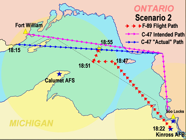 Scenario 2: F-89 and C-47 Intercept